Tracking
the Journey
-
Distance to go:
0 Mi
Distance
Ben and Tarka will cover 1800 miles starting from Scott's Terra Nova Hut at the edge of Antarctica to the South Pole and back to the coast again. That's equivalent to 69 back-to-back marathons hauling up to 200kg each (the weight of roughly two adult men) of kit and supplies necessary to survive.
Distances here are shown in statute miles.
Not Much Easier (Day 27)
Day 27: S80° 39' 34.02", E168° 49' 21.9"
Duration: 8 Hr
Daily distance: 14.6 Mi
Distance to go: 1573.7 Mi
Temperature: -17 °C
Wind chill: -23 °C
Altitude: 213 Ft
Greg Lemond, the first American Tour de France winner, once said of racing bicycles as a professional that (and I may be paraphrasing slightly here) "It never gets easier, you just go faster". And so it goes in the world of professional sled-draggers too.
I found today pretty tough and struggled against my harness like an aging donkey, cursing the headwind, and at times even my own stupidity for thinking this was a good idea. Tarka, as always, soldiers on like a cross between a bionic Birdie Bowers and Dolph Lundgren, which of course is why I asked him to be my team mate. The word indefatigable was invented for Tarka, he has the heart and lungs of a racehorse, each thigh is a tree trunk, and his brain is a computer that processes complex calculations involving latitude, longitude and average speeds with alarming accuracy.
Once again we've hit a record distance (more than 14 miles) and I'm hoping this streak will continue. The weather was very odd today, with sunshine almost all of the time but an astonishing range of temperatures and wind speed and direction that had us juggling layers of clothing and mittens, gloves, hats, masks and headbands. At some points I was wearing almost everything I had, yet for half an hour this afternoon I skied in still, sweltering sunshine in just my base layer.
We saw mountains a long way off to our right (pretty much due west) possibly the Churchill Mountains or the Britannia Range, blown out of proportion and distorted vertically by mirages. We should start seeing more land in the coming days as we trundle closer to Mount Hope, the Gateway and the Beardmore Glacier. Stay tuned...
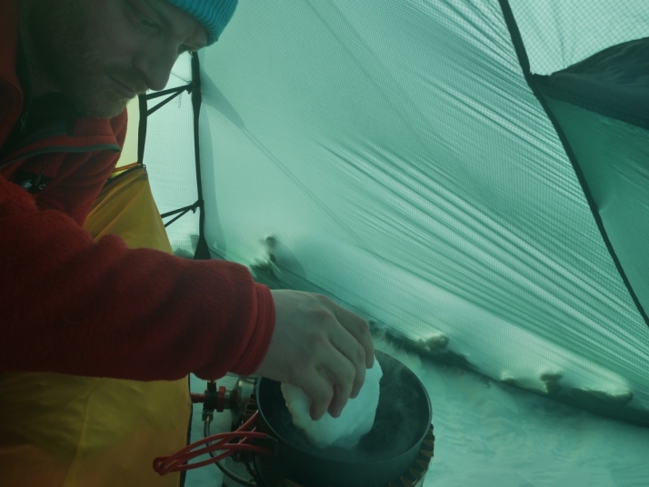
P.S. we were asked if we eat snow - today's picture is of me melting snow that would a few minutes later go into rehydrating this evening's dinner, chicken dhansak (thanks Fuizion!)


Comments
# Amy, November 21st 2013
WOW!! 14 miles…nice work! My Geography classes are checking in with you every day!! Thanks for the great adventure!
# Andrea, November 21st 2013
What a magnificent journey, guys! It’s a privilege to follow your progress day by day. Best of luck!
# dj, November 21st 2013
The geo-waypoint marker seems to stop around about 1pm here in the US Mountain Daylight Time and I notice that they made another (un-official) 14.7 miles today - just short of another degree marker by 8.8 miles, which they should make tomorrow (God willing and the creek don’t rise). Pretty much abeam the Entrikin glacier to their left (west).
It took them 7 days to do the last “degree” and will (most likely) take them only 5 to do this one.
# Kristoffer, November 21st 2013
By my estimate, made by zooming in and holding up a ruler to my screen, they’ve actually managed 14.8 miles.
# Kevin Wilson, November 22nd 2013
Mistake in the frequently asked questions section…What type of skis are using?
Traditional skis must be heavy if the ones they’re using are 300kg each lighter.
# Scott Expedition Team, November 24th 2013
Thanks Kevin. They would indeed. It should read 300g and has been updated now.