Tracking
the Journey
-
Distance to go:
0 Mi
Distance
Ben and Tarka will cover 1800 miles starting from Scott's Terra Nova Hut at the edge of Antarctica to the South Pole and back to the coast again. That's equivalent to 69 back-to-back marathons hauling up to 200kg each (the weight of roughly two adult men) of kit and supplies necessary to survive.
Distances here are shown in statute miles.
No Easy Miles (Day 66)
Day 66: S88° 58' 43.56", E157° 53' 21.72"
Duration: 10 Hr 30 Min
Daily distance: 21.6 Mi
Distance to go: 827.8 Mi
Temperature: -22 °C
Wind chill: -30 °C
Altitude: 9888 Ft
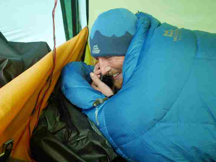
Tarka called today "Unequivocally the toughest day of the expedition" and it certainly ranked up there with the most challenging for me too. Perhaps naively, we thought that the mileage would come relatively easy on the flat(ish) plateau with our sleds at their very lightest, but Antarctica always seems to have a way of showing you who's boss and we've really struggled hard for every metre today.
We'd set ourselves a target of 36km per day until the next depot, but I called it a day just shy of 35km this evening after about ten hours on the move, and with Tarka getting worryingly cold as the temperature dropped. Thankfully I seem to be a human furnace and usually wear one layer less than Tarka when we're on the move, though of course the flip side is that when he's on form I have to bury myself to keep up with his lanky strides.
We'd thought we'd be able to retrace our tracks all the way to the top of the Beardmore, as Shackleton and Scott did, but we lost them yesterday in a lot of fresh snow and in a very flat light when the ky clouded over for an hour or so, so we set a bearing straight for our last depot -as of course unlike the men here a century ago, we have its coordinates saved as a GPS waypoint- only to rediscover our old tracks again this afternoon.
We seem to have passed through a weird Bermuda Triangle up here near the Pole; our satellite tracking beacon is on the blink and has turned itself off twice now, with a battery indicator that goes from full to flat in a few minutes, and our spare GPS (a little Garmin Gecko) conked out a few days ago and needed a hard reset that deleted all its waypoints. In addition, our main GPS was giving us some very wonky magnetic bearings to follow as we approached the Pole, but it seems to have sorted its act out now. It's quite alarming to realise how much faith we have in these tiny gadgets, and how utterly reliant we are on them to find our depots on the way home.
It's another late night now here (nearly 11pm as I type) so I'm going to sign off now. We're rushing to get off the plateau, but we pick up our Pilot at the depot so we'll have way more bandwidth for videos, decent photos and answering questions again. Thanks for following as we trudge north again, and sorry if I'm moaning a bit at the moment!


Comments
# George Chapman, December 30th 2013
I notice again today the tracking system on Google Earth is not showing any movement so I presume the guys are still having some sort of problems with electronics. I hope this is not affecting their proper navigation. They need to be careful way down there on the bottom of the Earth I don’t want them falling off.
I hope folks don’t think I’m complaining there are several comments here every day from people complaining about complainers. I don’t want to be thought of as a complainer by the complainers who keep complaining about those folks who are always complaining.
You guys are doing the best you can and we are all proud of you even though I do believe my 80 year old mother could do this faster.
# dj, December 30th 2013
Mine too George - and you wouldn’t have known she was doing it until it was over and she dropped the fact nonchalantly into a compound sentence some evening in a non-related conversation. (That was she could have, until she got her walker when she turned 90).
AND, I too do NOT want to be counted among those who people think are complaining about complainers complaining. I think my record is very clear in stating that everyone is entitled to describe things as they feel them without being called a complainer; because telling it like it is, as everyone knows, isn’t really complaining. [Actually, I just couldn’t resist adding to your play on words - I’m not poking fun or doing anything else politically incorrect either.] [“Oh, we of little wit!”... Ben Franklin]
Hang in there guys, we tease the ones we love and even though none of us can see your little dots moving on the map today, we know that you are down there still doing your thing heading towards your battery chargers - (oh, and home too.)
# Sheila England, December 30th 2013
You are allowed to moan,...esp. after all that happened. Hang in there Kiddo!
Hugs!
- Sheila
# Nick, December 30th 2013
Nearly under 800 miles in the right direction. I’d be pretty happy with that thought. Prince Harry only managed 200 before he was whisked off back to his plush Buckingham Palace and what? Second girlfriend? What happened to his first? Anyway, The London tabloids keep us fit. Yeah keep us fit. Page by page of fitness. And wordsearch alogorhythms. Diets and front page spreads. Cheese and chocolate calorie free. And plenty of darling nice sexy Victoria Beckham in black dress and is she yet a Lady? Well we who worship her would want her to be Lady Posh, but maybe next year when they do more ‘work’. As for a Posh Lady?
We welcome that thought everyday.
Nevermind. Gale Force winds in the UK have died down to a breeze of a normal summer and New Year eve is just 1 day away. Anyway, what would I do when I finish a run in the summer?
A glass of cold Pepsi.
# torsten Richter, December 30th 2013
Hi Richard ,
True, I can not speak English so well , and use the translator . I am also of the opinion that no man may judge his mistakes from our present time about Scott . It has to be from the time 100 years ago, see , like the people at that time thought what they stood as help is available , and most importantly , there is none that ever was in Antarctica or an expedition led , can be put in Scott inside. I am extreme athletes have done it 100 marathons , including more than 40 marathons with over 45 miles and some with over 70 miles. I know that the will can overcome many problems and weaknesses with the necessary motivation , people can move mountains , and I know that one makes from 20 miles all just over my head. And I stick to it , Scott would have been the first at the pole or they would not have had bad luck with the weather and no injured comrades , they would have made the return journey. Definitely Scott was his character more than the Amundsen . The said to myself Amundsene Great Niece on 29.3.2012 in London, at the ceremony at the Scott Monument at Waterloo Place .
# Richard Pierce, December 30th 2013
Hallo Torsten,
Warst Du da, am 29 Maerz 2012, am Waterloo Place? Ich war naemlich auch dort. Schreib ruhig auf Deutsch, oder send mir email zu rps (at) rdsl (dot) com.
Thanks for answering :-)
R
# torsten richter, December 30th 2013
Hello Richard !
Yes, I was first in the service at St. Paul Cathedral and then at the parade on Waterloo Place . At this point I must say it was a very impressive and beautiful day in London. Your English is very cultured with your hero and traditions to . It was very yielding and I enjoyed the hours. I got to Scott’s grandson , the great-nephew of Wilson and the great- niece of Amundsen to know . An English lady helped me to translate and thus I was able to record a nice day. And exactly this route as Ben and I will Tarka for 3 years done by you but I still needed the sponsors. I myself am also extreme sports , ultramarathon doing 100 km and difficult mountain passes in Switzerland. For this expedition I want to be physically well prepared and I would perform this expedition also in the name and memory of Scott. This is my biggest dream . What exactly do you do ? Are you a writer? Are you on Facebook? My name is as Torsten Richter from Brandenburg or via my e -mail can reach me .(JavaScript must be enabled to view this email address) . I would be pleased to communicate with you further . Kind regards from Brandenburg . Torsten
# Brendan Smith, December 30th 2013
I’m sure emotionally you can feel the end of the journey now that you’re on the return leg. But, like coming down from the summit of a mountain, I’m sure this can be a very dangerous time. Stay safe and God speed to you!
# George Chapman, December 30th 2013
I still notice we are not getting updates on Google Earth until the end of the day. I hope the guys are still being able to navigate using new technology or they may have trouble finding those depots. From their post today they said” It’s quite alarming to realise how much faith we have in these tiny gadgets, and how utterly reliant we are on them to find our depots on the way home.” So I hope this problem is solved. I have seen nothing today on FB or Twitter discussing this issue other than their daily morning post. I wonder if the home team is hearing from them on some regular basis.
# DJ, December 30th 2013
Well now. We see that the two are sending out ‘hourly pings’ from the same place they camped last night with some fair variability. Perhaps a ‘weather day’?
# George Chapman, December 30th 2013
#dj
I don’t understand how your seeing the pings. I asked this question yesterday but did not get a answer. I only see current position marks and daily blog markers. Can someone please answer this question.?
# Mal Owen, December 31st 2013
I would be interested in seeing these pings too !
# dj, December 31st 2013
Oops, my bad. All the ‘pings’ I saw at the tent site must have been from last night because their new update shows quite a movement today.
Seeing the actual track-points contained in a track-line of a trail in Google Earth is easy peasy. Merely select the trail line you want in the menu on the left of the screen, right-click on it and select “properties.” That will actually allow you to make changes in the line (edit it) but before you do that, zoom in to where you can see the line clearly and you will see all the little red squares (bumps) running along the line - those are the track coordinates. GE merely draws a line between all the coordinates you give it in your map file.
Assuming that the Expedition manages 1 track-point every hour (they’ve never actually told us the specifics) then those knobs are the coordinates that Ben’s technology sends out every so often. During the day they are moving so we have no way to actually know what “percentage” of the coordinate they send out is actual and how much of any one point is merely the “measurement/calculation error.”
However, when they are sleeping (and supposed to be stationary) each hour the new coordinates must be showing the “variance” if it moves at all. Hope this helps, looking at the details can actually be fun and enlightening.
# dj, December 31st 2013
George… sorry, didn’t see your previous question or I would have answered. I should warn you guys, looking into this depth of information on maps can be kind of habit forming and get you called a nerd.
Also, you do need to be quite close to the line in order to see the ‘points’ because they are quite small. Sometimes you are best to navigate to where the trail-line makes a sharp bend. Right at the crook is where a track-point is drawn.
And, in order to see the variance during sleep Richard and I have been talking about today, you need to be very close - tell you what, give me a second and I’ll put up a temporary example file on the web you can download and see it well. I’ll use Ben’s very own day 66 as the example. It’ll be right here: https://dl.dropboxusercontent.com/u/567495/Temp/66.kml Just download it and click on the placemark - it’ll zoom you right to where you can see it.
# dj, December 31st 2013
Ok the example is up and running at: https://dl.dropboxusercontent.com/u/567495/Temp/66.kml Down.load it and open it in Google Earth - its label will be “66”. Make sure Ben’s trail file is already open in your Google Earth because that’s what you’ll be looking at.
Double click on the “66” placemark I’ve given you and your screen will dive down to about 10,000 feet above the ground and you’ll see their “camp 66,” the trail coming in and going out and all the “hourly” refreshes of waypoints that were automatically made while they slept.
Right-click over on the Scott Expedition, Track line and select “properties” at the bottom of the pop-up menu. You’ll see all the track-points - which by the way you can click on and move around if you wanted to alter the trail (on your machine only - not the main file).
# George Chapman, December 31st 2013
#dj
Thanks for all the help. I downloaded your file and see what your speaking of. Thanks again.
# Tony Muilenburg, December 30th 2013
Hey, I just read about 22 photo negatives that were discovered yesterday up by you guys that were taken during Shackleton’s trip. Best of luck on the return trip.
# dj, December 31st 2013
Tony… read it again. The negatives were discovered a while ago by someone else - Ben doesn’t get the credit for this one.
# Intrepid, December 30th 2013
Curious whether the sun’s magnetic flip has had anything to do with the electronics issues.
# Offroading Home, December 31st 2013
I haven’t been been watching the news so didn’t hear anything about the sun until you mention it. HOWEVER, I just loaded up the government satellite overlay for Google Earth showing almost real time Auroral Activity and HOLY Crap - the image is nearly dark red! The strongest I’ve seen it in the two months I’ve been watching. (6:43 pm MST)
If you want to take a look at it to follow along I’ve got it as part of the Google Earth Antarctic Resource Map available for free download here: http://offroadinghome.blogspot.com/2013/12/scott-expedition-south-pole-by-boxing.html . Load the map into Google Earth and click on the box next to the menu label “auroral activity.” Be patient it takes awhile to load the graphic - The color scale is logarithmic, Yellow being the least, light orange being ten times greater and red being 100 times greater.
# Intrepid, December 31st 2013
Okay… I’ve got Google Earth up but seriously, I don’t know how to overlay your map onto it. You can be assured I have no clue what I am doing, that I don’t know where to paste or click or whatever it is I need to do to put your link into place, or how to get the gov satellite overlay… so please, instruct me in the fine details you would otherwise never think you would have to mention to anyone… and know that your efforts will be well received, as well as enjoyed.
Thanks!
:)
# Intrepid, December 30th 2013
Dear Ben and Tarka,
It’s always good news to hear you are okay!
Very interesting how the picture posted above is quite a juxtaposition from what is written below it. The photo is bright and colorful, smiling and happy, and then the writing conveys a different story about snow conditions, the cold, being tired, and technical issues. The weather and accumulated lack of sleep while pushing hard coupled with satellite gear going awry does seem of concern to my ears. I’m not in your physical condition, have never stayed long in extreme conditions and have no real dependency on everything working to a T as you perhaps need. I’m accustomed to electronic gear malfunctioning, so even though I have an iphone with a GPS and a GPS built into my car, I always carry backup maps. A few people have asked whether you are equipped with other modes for finding your way. It would be comforting to know the answer…
Blessings
and
Godspeed
# Mike, December 31st 2013
You guys rock. I have been telling all my friends here in Idaho about your inspirational efforts and heart. And when I tell my twin 17-yr old daughters about what you are accomplishing, they seem to truly understand (more than I can ever tell them) that anything is possible in their lives. What an inspiration you are to us all! Congratulations and best of luck.
- Mike