Tracking
the Journey
-
Distance to go:
0 Mi
Distance
Ben and Tarka will cover 1800 miles starting from Scott's Terra Nova Hut at the edge of Antarctica to the South Pole and back to the coast again. That's equivalent to 69 back-to-back marathons hauling up to 200kg each (the weight of roughly two adult men) of kit and supplies necessary to survive.
Distances here are shown in statute miles.
Round One Hundred and Two (Day 102)
Day 103: S78° 28' 59.05", E168° 30' 28.80"
Duration: 10 Hr
Daily distance: 23.7 Mi
Distance to go: 63.8 Mi
Temperature: -11 °C
Wind chill: -16 °C
Altitude: 161 Ft
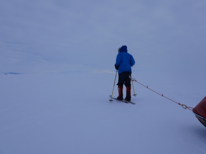
This continent seems to be throwing everything it has at us in our final few days. Today we slogged away under heavy cloud cover again, luckily with a sliver of horizon that - as you can see in the photo - gave us a glimpse of Black Island and made navigating relatively easy, though that was the extent of our view for ten hours on foot. The contrast was too poor for us to see the snow surface and the mess of small ridges and sastrugi underfoot, and it felt at times like we were trying to cross a frozen ploughed field on rollerskates. I fell over hard twice, and even Tarka (who lives in the Alps, whose mother is a ski instructor, and who I believe had his first pair of ski boots fitted shortly after his umbilical cord was cut) stacked it badly this afternoon. We laughed at each other when we slipped over three months ago, but now we're like two frail old men, living in fear of fracturing something in a fall at the eleventh hour of this Goliath trek.
Despite our proximity to the finish line, our sheer exhaustion seems to be standing in the way of us getting excited just yet, and lying in the tent in the evening getting psyched-up for another day of the same after too little sleep is never easy. Tarka's pep talk this evening contained one of his best lines yet: "Mate, we've gone a hundred and two rounds with Antarctica and we've won every one of them. Tomorrow we're going to win round one hundred and three."
That's all for now, as I desperately need some sleep! We plan to do a "normal" day of 38-40km tomorrow and then a jumbo last day on Wednesday 5th, with about 30km before picking up our first depot, where we'll pick up one day's food, pitch the tent, scoff it all, sleep for an hour or so and then carry on for roughly 25km to the shore of Ross Island. Watch this space...


Comments
# T.g, February 4th 2014
Not long to go now would be a mission complete after all that hard work. Bet you are looking forward to a nice warm home with a toilet and all needs. Will be able to have a lovely hot tea and see your family and rest at last.
# Kat, February 4th 2014
“A lovely hot tea”...Yes! Does anyone else recall that wonderful picture of Wilson, Birdie and Cherry after the horrors of the winter journey, that journey which beggared the imagination…Wilson staring full forward; Birdie just finished blowing to cool his tea, like it was any other work-day; and Cherry, poor Cherry, thick chunk of buttered bread, three more loaded and ready to eat on his plate, looking like he’d seen one or more of the rings of hell. Heroes all!
# Ian, February 4th 2014
I too will miss my daily dose of vicarious suffering, thank you both.
I imagine that you will be reflecting on Tom Crean’s astounding 37 mile solo walk to Hut Point, to get help for the moribund Lieutenant Evans, what a boy; though I am sure you would do it if you had to.
# Kat, February 4th 2014
Tom Crean! What a man he was…So many extraordinary stories of extraordinary men! Such integrity, strength of character, body, spirit.
# Kevin Wright, February 4th 2014
Hi Guys. I hope you both slept well and are totally refreshed for this new day. Non of us can have any idea the level of exhaustion you guys are experiencing! I wish I could do something , anything to help! All I can say is that the world is watching your every moment as you come to the end of an amazing journey. Keep your sites on your loved ones and all the reasons you planned this remarkable journey.We are all praying for your journeys end and a safe journey home. Take care, Keep Going and Gods Speed! Kev
# Willie Hannah, February 4th 2014
Ben and Tarka, the most dangerous phase of any operation is the extraction, keep you guard up until the last step. Be safe, Be strong, a truly Hoofing Effort. Willie
# Sheila England , February 4th 2014
My god, it must be so frustrating knowing the end is finally in site. Sleep well.
Take careful steps.
# Marina Kleinwort, February 4th 2014
OMG. I am without technology for 6 days and you are suddenly very close to achieving your dreams. How totally mind-bogglingly phenomenal. I wonder what the first thing you will do is when back in civilisation? I wonder if it will be hard to be to integrate with other people having just been the two of you for so long? I wonder whether you want to finish this trip quietly or even if that will be possible with the McMurdo base right there? So many questions: both serious and very silly, so hurry back to safety, eat, sleep and come back to the UK soon please!
# Sheila England , February 4th 2014
It’s bound to be a sensory/culture shock.
# Brian Warren, February 4th 2014
Gentlemen, I’m rooting for you! Keep up the great work. Godspeed!
# Andy E, February 4th 2014
One hundred and two rounds behind you & 63.8 miles left to before you, impeccable & inspirational, scathed & starved yet unbeaten & humble- qualities of the great explorers you both undoubtedly are. Proving that the unobtainable extremes can be met (but by no means Conquered) with measure and the application of grit. There are few alive who’s footsteps have strode your path and none that ever were that equal . Far from over is the psychological distance afore you within the ‘final push’yet so close are the rewards of your near immeasurable labour.
If ever we meet i would be honoured to make for you a roast dinner of such proportion as to match your calorific loss you have given in the name of exploration!
# Enrico, February 4th 2014
so, you are almost at finish line! well done Ben & Tarka
# Offroading Home, February 4th 2014
Andy… since we now know that you are still behind your desk, I wonder if you might do all of us “watchers” a HUGE favor and ask them to turn up the frequency of their transmitted trackpoints, not for the whole duration but at least for that “last slog of about 25 km” after their final “cat nap.” I figure you set the “hourly” ping because you you were worried about power consumption and batteries; but, they seem strong now and that would give a more “real time” and actual “break-the-ribbon” aspect to it. If you could afford a setting of every 10 minutes you’d probably stand a much better chance of actually catching the trackpoint which documents the end of the journey (I feel bad about not reminding you to do the same thing at the South Pole - but there was other issues there as we know.)
# Heidi, February 4th 2014
DJ, My Google Earth-reading skills are rudimentary. Where is the “exact” location of Ben and Tarka: are they where I see your tent icon, or is it the red “pin” that’s a few miles back? Thank you for clarifying.
# Offroading Home, February 5th 2014
@Heidi… the Antarctica Resource File is not “real time” - it relies on the published data from the expedition. It is also hand-crafted - meaning not automated like the expeditions. Therefore, at any one moment you may see pointers move, or lag behind which usually means I’m working on that file at that moment and refreshing your map a moment later may cause the icons to flip into position.
All that said, as you can see, the Resource Map goes much beyond what the expedition’s map is set up to do - they’ve got other things on their mind. Our Google Earth file tries to be as up to date as it can be (but I’ve got to sleep some time) but it not definitively current. If you want to see timings, descriptions of where they are, speed/direction/location calculations, comparison maps of other explorers, web cams, south pole station maps, satellite ice sheet images, and tons of labels on geological places that Google Earth doesn’t show—- well, this is your file.
This isn’t the first expedition that we’ve followed with resource maps and we’ve decided that once this expedition is completed we’ll make a permanent map out of it and place it on our web server for all to see and reference.
# Heid, February 6th 2014
Thank you for the explanation. And glad to see I’m not the only one who has put in some late nights/early mornings waiting for current info and posts from the expeditioners.
# jan, February 4th 2014
What a friendship. We can only glimpse in the desciption of your journey your hardships , and can only continue to wish you the very best in the last few days. We know someone who will be very pleased and relieved to have you safely home..
# Sam c, February 4th 2014
Good luck with the final stretch, i’ve really enjoyed following your adventure and think that you have shown us that it’s not all about the final result but in the journey itself. You have demonstrated that no matter how tough it’s going to be any journey is both easier and more enjoyable with solid teamwork, friendship and total respect for each other. Well done guys.