Tracking
the Journey
-
Distance to go:
0 Mi
Distance
Ben and Tarka will cover 1800 miles starting from Scott's Terra Nova Hut at the edge of Antarctica to the South Pole and back to the coast again. That's equivalent to 69 back-to-back marathons hauling up to 200kg each (the weight of roughly two adult men) of kit and supplies necessary to survive.
Distances here are shown in statute miles.
An Off Day (Day 47)
Day 47: S85° 24' 7.2", E159° 50' 32.64"
Duration: 9 Hr
Daily distance: 17.5 Mi
Distance to go: 1222.2 Mi
Temperature: -24 °C
Wind chill: -36 °C
Altitude: 8074 Ft
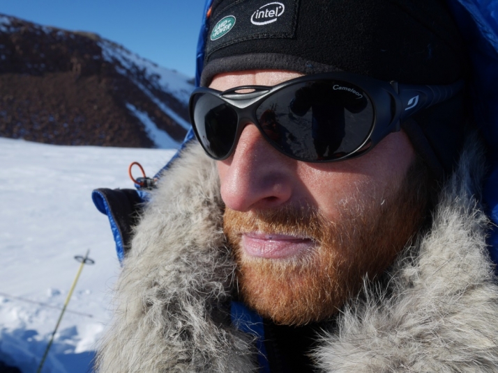
There was some big talk in the tent last night of getting a 38km day today, and once we'd buried the depot we set off over what seemed flat terrain at a breakneck pace, enjoying towing sleds that were lighter than they'd ever been on this expedition. Things started going wonky after the first hour: we were going uphill again, then we started turning south a kilometre or two sooner than we should have done, getting caught up in the far western edge of the Shackleton Ice Falls.
What looked like a clear-ish way through to the plateau ended up being a bit of a nightmare. Eventually we admitted defeat and partially retraced our steps, heading further west before finding a good route for our final ascent to the plateau. Physically I was near rock-bottom today. We're both tired from the last 46 days of slog, but for some reason I suffered like a particularly unfortunate dog, my legs feeling empty and my body struggling to get out of second gear. I felt woefully weak towards the end of the day (and it's been a very long day: we took the tent down at 7.30am and didn't clamber into it again until 8.45pm) and struggled to control the downward spiral of my mood and self-talk.
Lying here now (10pm, we're just about to eat dinner) things don't seem too bad, and I'm hoping for a miraculous recovery in the six or seven hours of sleep we're averaging. The good news is that we're now on a straight line bearing for the Pole, heading due south, and at nearly 2,500m above sea level tonight, almost all of the serious climbing is behind us. More soon... P.S. It's getting chilly again!


Comments
# CaninesCashews, December 11th 2013
Sounds like a hellish day on the ice – combined with a ‘completely knackered’ day, not a good combination.
You seem to be beating yourself up, but you still managed over 17 miles on what was effectively the transition area to get on to the Plateau proper. No mean achievement.
Unfortunately I’m sure this isn’t going to be the only day that you are going to feel like you are running on empty, it is how you deal with it and bounce back that is important.
The American baseball player Sam Ewing said, ”Hard work spotlights the character of people: some turn up their sleeves, some turn up their noses, and some don’t turn up at all.”
You’ve already turned up, and the sleeves thing; I think you’ve got that covered.
Straight on to the pole now with renewed vigour (and a lighter sled)!!
Stay safe.
Gav
# George Chapman, December 11th 2013
A little mishap getting started still got you 17.5 MI. Your on the final stretch now and when you get to the pole you will deserve several days rest. Glad to see the weather has been good the last week. You guys take care of yourself be careful and enjoy the view. Were all here enjoying your every post and photo.
George
# pfong, December 11th 2013
Well done on the good mileage despite the difficulties. Keep on trucking!
# Alexandros Kaloudis, December 11th 2013
Actually I was wondering if you are machines or humans. 46 days -on the row- hauling the sledges and no sign of fatigue!!?? You know better than me, that this “emptiness"was expected ( especially after Beardmore ).
I’m sure you’ll be back “on track”. Glad sharing your amazing experience with us. My 9 year old daughter is watching your progress on the map every day, and asks for details of your days down there. Stay safe.
Alexis
# Richard Pierce, December 11th 2013
Don’t be down on yourselves; you did over 17 miles, which is good going especially compared to earely days. You’re bound to be knackered after climbing old Beardmore in a comparatively short time. Don’t look forwards, don’t look backwards, just do.
Sleep well, and regain strength, and talk to yourself tomorrow about the now.
R
# John Brain, December 11th 2013
A very trying day for Ben and Tarka, and congratulations to them for doing as well as they did.
Shackleton too had tremendous problems at this stage, and additionally, his party’s loads were so heavy that they had to relay at this point. (meaning that they doubled up on sledge-hauling, returning for the second sledge and thus travelling 3 miles for every one mile gained).
I note that Ben and Tarka are at 159deg 50’ E. and have now turned from a SW to a due S direction. To avoid the chaotic crevasse region as much as possible, Scott proceeded further SW to 159deg. 31 E. before he turned S. I am left wondering why Ben and Tarka turned as early as they did. But easy for me, commenting from the comfort of a warm room, and with no experience whatsoever, except what I read in books!
# DJ, December 11th 2013
John… I really enjoyed the effort you put into your post yesterday giving the correlations - what a Scott Scholar! I think you can answer your own question from today by looking in Google Earth and opening the resource file that we made [ http://offroadinghome.blogspot.com/2013/12/scott-expedition-resource-map-update.html ]. I’ve just updated it to include a grid line based on the coordinates you gave. It’s the purple line at 159.517 degrees (decimal equivalent) and as you can see, it wouldn’t buy them much.
However, if you also turn on the “MODIS Satellite Image” (click the box next to it’s label) you can see that it would go through even worse terrain than what they are on. There is also another route for Scott’s journey in the “Historical Expedition Routes” folder that I found on the web somewhere. Click that box on and you can see it in green. I don’t know where they got their track points but it clearly runs right through the Skackleton Ice Falls and is quite a bit more east than your coordinate.
The yellow line that I’ve labeled “Historic Scott Route” was actually drawn by me several months ago based on the easiest and quickest route I could see based on satellite images (I wanted to see if they would take it).
However, as you can see from the track they are leaving today (11th day after this post), they seem to be merely plowing through the terrain, closer to your coordinate - more difficult and exhausting, I would assume, but perhaps more accurate.
Fortunately, ALL points south of where they are lead eventually to the same place!
ps - If you’ve got a list of all the “official” Scott Waypoints I’d be happy to program them into the resource file as a track.
# Jon, December 11th 2013
Guys - amazing progress. Don’t worry about the weak legs, it is most probably due to the altitude, you should be feeling it now. 2500m near the south pole, feels more like 4500m at the equator. Many people who fly directly into the south pole station without acclimatising feel terrible for about a week. I have heard that effective altitude at the pole is nearer 5750m when physically you are just under 2900m - so liken it to being on the summit of Kilimanjaro. Then your hollow legs won’t feel so bad. Tarka is probably OK as he lives in the alps.
Take care -you’ll be back at your cache in no time.
J
# Rayna, December 11th 2013
38km sounds like a huge accomplishment especially in the conditions you’ve been in. Incredible stamina and then to read your words: “... things don’t seem too bad.” I sit here in a chilly NYC with sprained ankle and suddenly feel pretty wimpy—i may go out for a run, now :) From what I have read of other expeditions, this type of fatigue is normal. Food, good colleagues, and rest will most definitely heal. Stay warm, sleep well, and good travels!
# robin, December 11th 2013
another fantastic day ben . well done one quick question. What ime does it get light and what time does it go dark or does the sun never set?
# Willie, December 11th 2013
Ben and Tarka, Fantastic achievement today 17.5 miles on what felt like an empty tank. remember, this is one helluva Antarctic marathon, and within that you will have good days and bad days, short and long days. Don’t beat yourselves up over it, if it felt hard, it probably was, just think that once acclimatised, with lighter sledges and less inclines the miles will come again. Take each day as a battle, to win the war. Be strong, be safe, pat each other on the backs. Willie
# Linda, December 11th 2013
Just saw the youtube film, you hauling the sled. I cant believe you do that , hours and hours a day in those circumstances . You guys are awesome. I read your blog everyday when I come home from my officeday. Its breathtaking. You both stay strong and healthy. You can and will do it :))
# dj, December 11th 2013
@John… I really enjoyed the effort you put into your post yesterday giving the correlations - what a Scott Scholar! I think you can answer your own question from today by looking in Google Earth and opening the resource file that we made [ http://offroadinghome.blogspot.com/2013/12/scott-expedition-resource-map-update.html ]. I’ve just updated it to include a grid line based on the coordinates you gave. It’s the purple line at 159.517 degrees (decimal equivalent) and as you can see, it wouldn’t buy them much.
However, if you also turn on the “MODIS Satellite Image” (click the box next to it’s label) you can see that it would go through even worse terrain than what they are on. There is also another route for Scott’s journey in the “Historical Expedition Routes” folder that I found on the web somewhere. Click that box on and you can see it in green. I don’t know where they got their track points but it clearly runs right through the Skackleton Ice Falls and is quite a bit more east than your coordinate.
The yellow line that I’ve labeled “Historic Scott Route” was actually drawn by me several months ago based on the easiest and quickest route I could see based on satellite images (I wanted to see if they would take it).
However, as you can see from the track they are leaving today (11th day after this post), they seem to be merely plowing through the terrain, closer to your coordinate - more difficult and exhausting, I would assume, but perhaps more accurate.
Fortunately, ALL points south of where they are lead eventually to the same place!
# George Chapman, December 11th 2013
Dj I have gone to the page you mentioned several times looking for file you have mentioned and this is what I see.
Offroading Home has developed an extensive Google Earth Resource File which brings all the meaningful resources together in one place and it’s available free: Google Earth Trail FileScott Expedition: Antarctica
When I click the link I get a notice saying Adobe reader could not open the file. I already have the Scott Expedition app loaded into my Google Earth but I do not have your MODIS Satellite Image. I do not need to reload the whole Scott Expedition app. Can you give me some help.
# dj, December 12th 2013
George… be glad to help. I don’t know how to get you the direct contact email via this blog except to perhaps to say use the contact link on http://offroadinghome.djmed.net The .link on this page: http://offroadinghome.blogspot.com/2013/12/scott-expedition-resource-map-update.html - leads to a download of a Google Earth .kmz file (having nothing to do with anything that Adobe should be opening). Clicking on the link should give you the Google Earth file - and should ask if you want to save or open. If you have Google Earth loaded on your computer, clicking “open” should open the file directly in GE - AND should not interfere with any other file you are using at all.
If you want to communicate more I’ll be glad to help you troubleshoot, just let me know.
# John Brain, December 12th 2013
Despite having Google Earth, till now clicking the link you provided has got me nowhere. But the new link you provide in response to GC’s problem has finally got me there. And it’s excellent. Many thanks.