Tracking
the Journey
-
Distance to go:
0 Mi
Distance
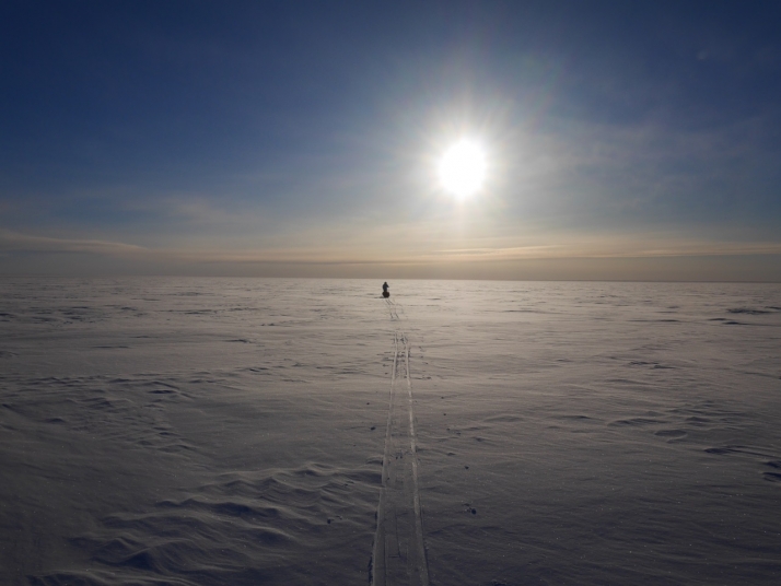
Ben and Tarka will cover 1800 miles starting from Scott's Terra Nova Hut at the edge of Antarctica to the South Pole and back to the coast again. That's equivalent to 69 back-to-back marathons hauling up to 200kg each (the weight of roughly two adult men) of kit and supplies necessary to survive.
Distances here are shown in statute miles.
Blog Delayed (Day 17)
Day 17: S79° 0' 46.188", E168° 32' 20.4"
Daily distance: 7.8 Mi
Distance to go: 1687.8 Mi
Altitude: 174 Ft
Ben and Tarka weren't able to send their daily blog post last night as there were issues with the Iridium satellite system globally. It looks like the system is up and running again now so all being well today's post shoud come through as usual.
Word is that conditions are tough but they are both well and making progress. Those following the tracking may have noticed they yesterday reached 79 degrees South!
If you haven't already - vote now for your favourite pic from the first fortnight. Today's image is the current leader. If you think otherwise have your say by spreading the word and 'liking' your top choice on Facebook. Entries close Monday 11 November at 11.59pm GMT. The most liked image will become our cover pic on YouTube and Facebook.


Comments
# CaninesCashews, November 11th 2013
Very nice to see the guys have busted the 100 mile mark and hit the 79 degrees.
I have done another Etch-a-Sketch to celebrate! pic.twitter.com/fOyIw9g4QY
Gav
# Kristoffer, November 11th 2013
Very impressive artistry!
# George Chapman, November 12th 2013
Nice looking drawing. Thanks for sharing this
# Nick, November 11th 2013
I think this is good progress, and very real conditions. it’s not an indoor athletics arena. The mileage you’ve already done to the days I think is proving it’s right on track. If you get to the 1000 mile, that’ll be a real achievment. Every mile is a mile done !
# joe, November 11th 2013
Will Ben and Tarka be revealing all of the details of the depots they are laying soon… we heard very early on from Ben about the plans for his first depot - and there have been many questions from the followers - yet no answers as yet. Runny noses , whilst amusing ( I get a runny nose here in UK when its chilly!) are not quite as interesting as the Expedition plan for those of us who like to understand the true expedition delivery.. Can we have some detail on how and where he has been leaving his supplies.? I too am keen to know who holds responsibility for these depots as I believe there are many rules and regs about the Antarctic Heritage and how things happen down there…Cheers Team. .
# Scott Expedition Team (Chessie), November 11th 2013
Hi Joe, more of the operational questions will be answered once the full support team are back in London (expected mid next week).
# joe, November 11th 2013
Thanks chessie - I thought Ben was answering the questions in his blog? I for one am really interested in the operational and more day to day activity and would like to hear more about it - including depots etc - from Ben and Tarka. Perhaps he will pick up over the next couple of day in his blog. Thanks Again.
# Offroading Home, November 11th 2013
If you haven’t looked at Ben and Tarka’s GPS trail on top of the MODIS overlay in Google Earth you should. The USGS (US Geospatial Survey) makes the images from the MODIS (Moderate Resolution Imaging Spectroradiometer ) satellite system available as a Google Earth overlay. It’s available in the a href=“http://offroadinghome.blogspot.com/2013/10/scott-expedition-resource-file.html” title=“Unofficial Scott Expedition Google Earth resource map”>Scott Expedition Google Earth Resource Map</a> and gives a much better background for Antarctica than the completely white image included in Google Earth.
MODIS takes a completely new image of the entire earth every two days and has sensors (not cameras) that map geo-resources (like ice cover). I discovered its accuracy a couple of days ago but wanted to wait and verify with a few more points on their track. Today’s update shows that Ben and Tarka are definitely following the undulations in the ice shown clearly on MODIS - seeming to change their angle of attack up and down slopes.
Zoom in quite close to the track, click to put North at the top of your screen (so the shadows are correct) and follow along the track line. You see that the track takes subtle turns corresponding with the ice undulations in the satellite image. Even though we haven’t been told the timing of how the team is gathering their ‘fixes,’ they seem to be often enough to correlate with the topography changing their angle of attack up and down slopes.
Not real detailed - but real neat! [Download the map from the link above, open in GE, click on the MODIS Mosaic Antarctica box]
# Kristoffer, November 11th 2013
I already have it downloaded, but thanks for reminding us! Also, the comments system doesn’t allow HTML.
# dj, November 11th 2013
# Kristoffer… Glad you’ve used it. The comment was not so much about the file that has been available for a while but the new use I’ve discovered for the MODIS link that’s in it. Do you agree that it looks like their route is corresponding to the topography shown? I’m guessing that where it doesn’t seem to, it may be because the timing of the coordinates didn’t quite mesh.
Re the HTML - I realized that bold and italic haven’t been accepted from before but this is exactly how I’ve always embedded links and thought that was how all the others were doing it as well. Ah, I see. Triple checked, but messed up the code: <a >Scott Expedition Google Earth Resource Map</a>
# Kristoffer, November 11th 2013
Yes, when I’m zoomed in I think their turns do generally correlate with the ice contours.
# dj, November 11th 2013
Hmm, seems things have changed. Removed embedded link functionality now? The cut/paste link is: http://offroadinghome.blogspot.com/2013/10/scott-expedition-resource-file.html
# dj, November 11th 2013
New I’d get it in the end - things are automatic now. Doesn’t allow for friendly titles but easily works none the less.
# George Chapman, November 12th 2013
I have been following the expedition from the beginning but I’m not sure I’m getting all the detail you mention. How do I know if I’m using the overlay you mention here. In your post you said “open in GE, click on the MODIS Mosaic Antarctica box” I do not see a MODIS Mosaic Box” What exactly do you mean by “BOX”. If this file needs to be on my computer, what is the exact name of the file and where should it be located on my computer. Thanks for your help. I did a search on my computer for a file named “MODI..” but found nothing.
# Kristoffer, November 12th 2013
George, you open up the file in Google Earth by opening up Google Earth (assuming that you saved the file to My Places). Then the path to the MODIS overlay is Scott’s Trip>Robert Scott’s Expedition>MODIS Mosaic Antarctica. The MODIS overlay is between “Antarctic Glaciers” and “1961-62 Antarctica”.
# George Chapman, November 12th 2013
Kris. Thanks for you post. I installed GE on my computer about three weeks ago when this expedition began. It was installed on my computer here: C:\Program Files (x86)\Google\Google Earth\client. It put a shortcut on my desktop so that is what I use to launch the program. I looked in the above folder but I see no files or folders “Scott’s Trip>Robert Scott’s Expedition>MODIS Mosaic Antarctica” as you mentioned in your last post. I am seeing all sort of icons on the map where I can click on and get info so maybe I’m already using what you are mentioning and just don’t know it. When I open GE It automatically opens up to the Scott Expedition and there is a little Globe on the side bar named Scott Expedition. Do you think the proper overlay is built into this globe icon named Scott Expedition? Everything works find I see the current path and the stopping points. I do see mountain ranges it’s not just flat white land. Any comments would be helpful.
# Kristoffer, November 12th 2013
Silly me for using the path analogy.
Download the .kmz file from dj’s link, open the .kmz file in Google Earth, and save it to My Places. Then under My Places, go to Scott’s Trip, open the folder Robert Scott’s Expedition, then scroll down to find the MODIS Mosaic Antarctica.
# George Chapman, November 12th 2013
Thanks Kris
# Shaun, November 11th 2013
I’m curious if you rope up together in case you run over a crevasse. Having read a lot of historic accounts of the trek to the pole where there are many crevasse crossings, and accounts of explorers falling into them and being saved by being roped to their sled and comrades, wondered what your strategy is for hidden crevasse dangers.
# Scott Expedition Team, November 20th 2013
Crevasse rescue training was part of Ben and Tarka’s training expedition in Greenland earlier this year. Here’s a video about it https://www.youtube.com/watch?v=eQnULtVPCE0&list=PLUAuh5Ht8DS3CRil8b5TXG1s5XZHpXfnN
# Vic Vicary, November 11th 2013
On this Armistice Day…Lest we forget: The Pole Party from the Terra Nova Expedition:
-Capt R.F.Scott
-Dr E.A. Wilson
-Lt L.E.G. Oates
-Lt H.R.Bowers
-P.O. Evans
God Bless their souls
You are in the footsteps of giants…
Keep on striving, seeking, finding and never yielding.
God’s Speed guys
Vic Vicary - Team Scott: Scott-Amundsen Race 2011/12