Tracking
the Journey
-
Distance to go:
0 Mi
Distance
Ben and Tarka will cover 1800 miles starting from Scott's Terra Nova Hut at the edge of Antarctica to the South Pole and back to the coast again. That's equivalent to 69 back-to-back marathons hauling up to 200kg each (the weight of roughly two adult men) of kit and supplies necessary to survive.
Distances here are shown in statute miles.
The Route (Part 2) - Ross Sea & on to the Ice Shelf
Leaving the site of Captain Scott’s hut at Cape Evans, the first three days of Ben and Tarka’s journey will take them across the frozen surface of the Ross Sea as they head South towards the Ross Ice Shelf. To begin with, their heavy sledges will very likely run friction free over the sea-ice as Weddell seals and Adelie penguins observe their progress from the shore.
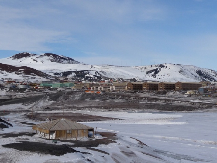
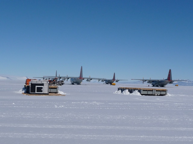
This area of the Ross Sea is dominated by the US administrative and scientific base at McMurdo Sound. Scientists on skidoos will course back and forth across the sea-ice, the sound and sight of helicopters will be commonplace and once a day a C-130 aircraft will arrive from New Zealand and land at the nearby airstrip. Frustratingly for Ben and Tarka, the hand of man will be everywhere.
Their first night’s campsite may well be in the vicinity of Hut Point where Captain Scott built his ‘Discovery’ hut. At sea level, with no wind and under constant sunlight the temperatures may well be only just below freezing, making the nights uncomfortably warm inside the tent. I expect it will take the team a few days to get into their stride but we should expect daily distances of 7 to 10 miles a day at this stage – perhaps more. But I would be surprised if their appetites will have settled yet so do not be surprised to hear of them not finishing their daily intake of food until a week or so into the journey.
After no more than a couple of days, Ben and Tarka’s route will take them under Observation Hill and past Scott Base, the New Zealand science station where they will leave the Ross Sea and move onto the Ross Ice Shelf. There is no discernible climb just a narrow area of disturbed ice along the shore line which they will pass through with ease. In the distance will be the sight of the William’s Air Base which they will be eager to pass by but it will be another day of hauling before that happens.
By moving onto the ice shelf there will be a noticeable difference in the weight of their sledges as they will now be travelling over snow rather than the sea-ice. This will be hard work and they will now feel the full load of their sledges. Some areas may well be packed hard by the wind but they must be prepared to face a softer surface where the tracks of their skis and sledge will run deep.
The route they should take at this early stage must avoid the crevassed area of the ice shelf close to land so they will have to swing out towards the East, avoiding the area that caused difficulties for both Scott and Shackleton.
There will be plenty of landmarks to see at this stage – White Island, Black Island and Mount Discovery to the West and the unmistakable shape of Mount Erebus behind them. After four days or so into their journey, they will leave the signs of humanity and head on a bearing 400 miles Southwards to their entry point through the Trans Antarctic Mountains.
Text and images thanks to Henry Worsley
This is the second in a six part series of Henry Worsley giving an insight into Ben and Tarka's route through his own first hand experience. Further posts will include 'the early stages of the Ross Ice Shelf', 'Mount Hope and The Gateway','The Beardmore glacier' and 'The Polar Plateau'.
 Enlarge
 Enlarge


Comments
# John Martinez, October 22nd 2013
Polar bears
# Kathy Frost, November 2nd 2013
Excellent post! Very interesting to note that they will not be doing longer daily marches…these distances are not unlike the distances that the early explorers did, with their very different technologies!