Tracking
the Journey
-
Distance to go:
0 Mi
Distance
Ben and Tarka will cover 1800 miles starting from Scott's Terra Nova Hut at the edge of Antarctica to the South Pole and back to the coast again. That's equivalent to 69 back-to-back marathons hauling up to 200kg each (the weight of roughly two adult men) of kit and supplies necessary to survive.
Distances here are shown in statute miles.
The Route (Part 4) - The Beardmore Glacier
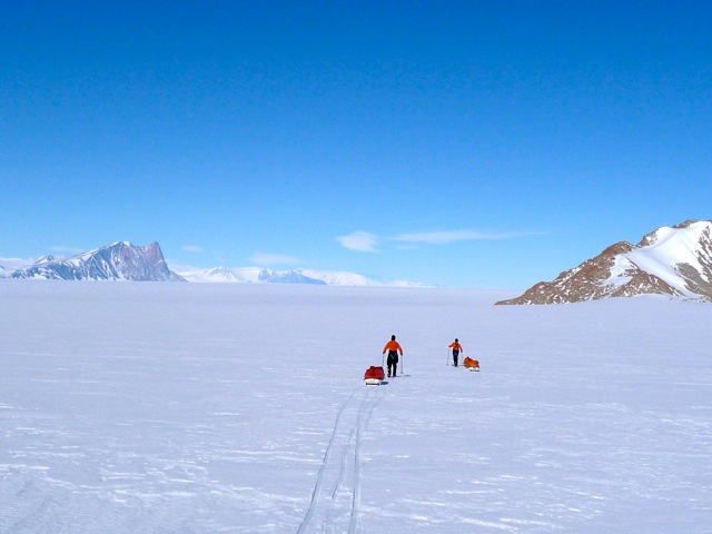
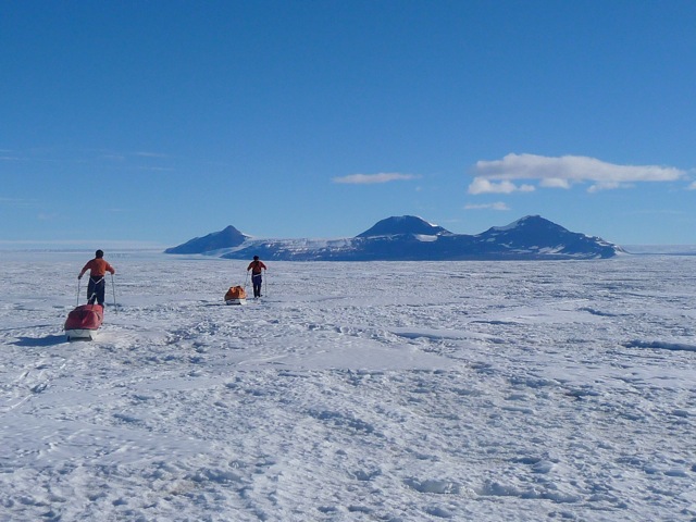
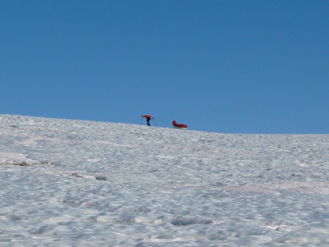
Discovered in December 1908 by Ernest Shackleton, the Beardmore glacier opened up a route through the Trans Antarctic Mountains to the polar plateau and the South Pole. It is one of the Antarctic’s great glaciers – 120 miles of crevassed titanium hard blue ice, 20 miles at its widest point, it ascends to 7500 feet and without doubt will prove to be Ben and Tarka’s most formidable obstacle.
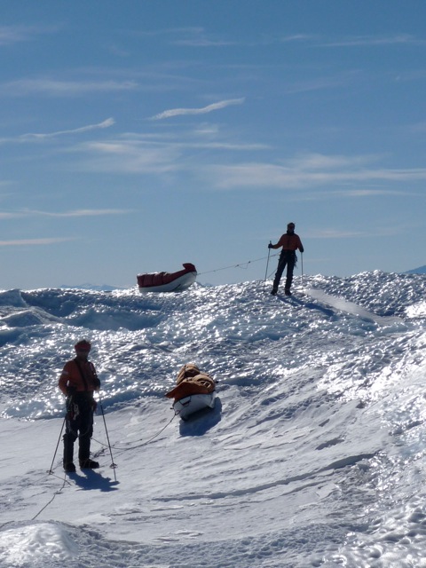
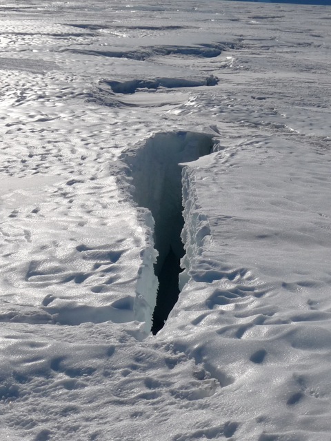
They will descend on to it from The Gateway marked on each side by the unmistakable outline of Mount Kyffin and the Granite Pillars. At first there will be enough of a snow covering to remain on skis but it is likely that they will rope up as they recognize the tell tale shadows and cracks on the surface of the hundreds of crevasses that lie in their path. These are not huge gaping chasms but narrow slits, well camouflaged that will easily take in and break a leg or twist a knee – especially when they travel on boots and crampons.
Their sledges will run much easier, friction free, on the blue ice, but they will have a mind of their own as they bump and crash along behind them. Their progress will simply be dictated by the amount of twisted and rubblised ice that they have to negotiate on the route they choose. Captain Scott stayed more on the Western side but there is no simple and easy way up it.
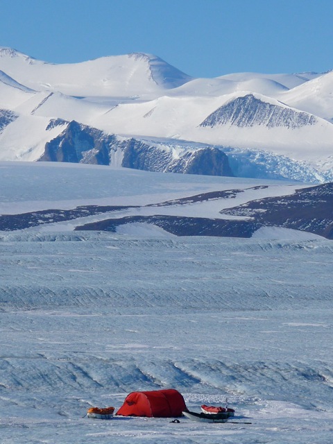
Camping on the glacier brings it’s own challenges. Due to the surface of blue ice Ben and Tarka will find that snow for them to melt for their cooking is in short supply and when it does occur in small patches it is full of fine sediment and moraine. They will have to use ice screws to secure their tent in high winds – otherwise it is food bags and the sledge to use as anchor points. They must be prepared for a hard night’s sleep unless they have well cushioned sleeping mats.
But the reward is the scenery – towering peaks on each side, glaciers feeding in from the valley sides and the silence, broken only by the crunch of their crampons and the irregular bashing of the sledges. Finding suitable locations to depot their food and fuel for the return journey will be challenging due to the maze of chaotic ice but an accurate GPS way point will ensure they find it.
The point of departure from the glacier is marked by a three peaked feature called Buckley Island. Whilst the daily gradient of the glacier will have been reasonably gentle, the exit is marked by climbing up a steep gradient of blue ice where the sledges hang off your hips as a solid dead weight. Sure footing is essential. They will probably rope up for the final time as crevasses are commonplace here as the ice tumbles off the polar plateau and down to the valley floor. Released from the grip of the Beardmore, their route will probably take them due South West for a day so as to avoid the impenetrable Shackleton Ice Falls where they do not want to be drawn into.
With their harnesses, ropes and crampons stowed at the back of their sledges Ben and Tarka can now focus on the remaining 2500ft climb to the polar plateau. It will be demanding work for the wind will be picking up and constantly in their face. But once again they will be heading South.
Text and images thanks to Henry Worsley. Video (The Route in 30 Seconds) by Ben.
This is the fourth in a now five-part series by Henry Worsley giving an insight into Ben and Tarka's route through his own first hand experience. The final post will give an insight into 'The Polar Plateau'. 'Mount Hope and The Gateway' and 'The Beardmore glacier' posts have now been combined into one.
 Enlarge
 Enlarge
 Enlarge
 Enlarge
 Enlarge
 Enlarge
 Enlarge


Comments
# Andy Lawrence, October 4th 2013
Hi guys. I came across your expedition in a newspaper yesterday and I’ve just finished reading your blogs. Respect and good luck for what you’re attempting and I’ll be following the blogs etc all the way. I’m also following the ‘Coldest Journey’ expedition who are moving north as you are moving south. I really like the videos (I could do with some information on the background tracks) and thanks for turning me on to Fuizion Foods, I will be buying some of that for my own stuff. Keep the blogs coming!
# Kristoffer, October 4th 2013
Good to see the recent press coverage has brought in new followers! Welcome!
# Scott Expedition (Chessie), October 15th 2013
Hi Andy. Great to hear you’re following along. The music for most of our videos is by Temujin Doran - he does all the filming, editing and composes a lot of the music as well. Here’s his website http://studiocanoe.com/
# dj, October 5th 2013
Enjoying this series. I wonder if it would be possible for the author to be a bit more specific about the locations of Buckley Island and the Shakleton Ice Falls. I found an old map which puts something called “Mt. Darwin” in the same vicinity but isn’t very definitive either.
Not finding any other specific maps of this adventure, I’ve been putting together a hand-drawn possible trail map with selected waypoints garnered from these and other narratives to compare with the actual GPS points eventually posted on this blog. The working map is located at https://dl.dropboxusercontent.com/u/567495/specialty/ScottExpedition-Antarctica.kmz for anyone who would like to look at it and will be updated as we follow along Ben And Tarka’s expedition.
# Francesca Beeching, October 15th 2013
Thanks for the link DJ. Just looking into more info on the exact locations above and will be in touch directly.
# Henry Worsley, October 18th 2013
Hi DJ
Buckley Island is made up of three peaks - Mount Bowers, Mount Buckley and Mount Bartlett. It’s location is 84’50 South 164’ East and the Shackleton Falls lie just to the Western side of Buckley Island.
If you are interested in a set of way points for the entire journey that Ben and Tarka are undertaking then you will find a very similar set, and a full description of the route and Shackleton’s diary entries, which I recorded in 2008 in my book “In Shackleton’s Footsteps”. (Forgive the shameless plug !). I hope that helps.
# dj, December 3rd 2013
Thanks Henry. I’ve placed the Buckley Island marker on the map at: 84°59’17.48"S, 163°44’47.47"E - the closest I could verify on Google Earth and with other sources. Mt. Bowers and Mt Buckley are also placed in that cluster.
Mt. Bartlett, however, is listed by Google Earth clear on the west coast of Antarctica, so we must be talking about a different Mt. Bartlett which isn’t listed in the official database that Google uses (neither is the term Buckley Island. As a side, neither is the “bump” Mt. Darwin (which for some reason I’ve got placed on the southwest side of Buckley Island. [Is that what you meant instead of Mt. Bartlett?]
This just really points out what a great benefit Ben and Tarka could be, if they will, to the scientific community (at least map makers) by merely documenting coordinates for the places they pass and see along the way. The databases of locations in Antarctica is still quite sketchy even in this day and age.
Thanks again.
# dj, December 3rd 2013
Oh, and I’ve moved the Shackleton Ice Falls (also not in the ‘official’ database used for maps) to the crumpled area SOUTHwest of Buckley Island where the MODIS satellite shows a bunch of disrupted ice structure. However, I notice that the satellite image shows a continued, significantly stepped structure for another 20 miles or so directly in the path they would be following so they can’t avoid that. There is even a more disrupted ice area to the south of the trail they’ll be following which is where I had initially assumed that you were referencing - they better avoid that too.
# dj, December 3rd 2013
Late Note: I still cannot find an accurate GPS listing for Mt. Bartlett in this cluster anywhere on the web or in other sources available to me. If you’ve got some, I’d appreciate hearing from you again if you would please. Or even a description of where it lies in relation to the other peaks in the cluster - I could then place a marker based on that. I don’t see that Ben and Tarka are publishing any coordinates as they travel so I’ll probably need to find them in some other place. Hope you can help. Thanks.
# dj, December 3rd 2013
Late, Late Note: Henry, it seems that only an hour of research wasn’t enough. It took over three hours and I think I’ve found all the coordinates you mention (except the ice falls) in obscure government mapping resources. They have all now been updated in the “un-official Scott Expedition Google Earth Resource File” available free at: http://offroadinghome.blogspot.com/2013/12/scott-expedition-resource-map-update.html
Thanks again for your help.
# dj, December 10th 2013
@henry late, late, late entry. I have now stumbled on a link to an old, official USGS Geologic Quadrangle map which shows LOTS of goodies, including both the Shackleton and Scott Ice Falls. It turns out that they are more south than west of Buckley Island (right where I had them placed at first from the disrupted satellite images). All the waypoints on the Resource Map are now correct. [ http://offroadinghome.blogspot.com/2013/12/scott-expedition-resource-map-update.html ]
# Cole , October 22nd 2013
This is really inspiring what you are doing. I’ve always thought of walking to the center of Antarctica. Or the center of the artic circle. But to be doing both is something else. I hope you have a really life changing event. I’ll be following you all the way through. Good luck